
Finding Cleburne Streets by Address
A Cleburne street search works best from the physical parcel rather than a broad name query. The Central Appraisal District of Johnson County links a Cleburne address to an account or geographic ID, owner spelling, property location, mailing address, legal description, values, exemptions, and tax year. Those Cleburne details make a repeatable trail. The Cleburne property location is the key for maps, permits, plats, and deeds. A Cleburne mailing address only shows where tax correspondence goes, which can be somewhere else. Public Cleburne ownership information is useful evidence, but it does not identify every person currently connected with a property.
- Search the address at Johnson CAD Property Search. Try the Cleburne street number and name first; if that fails, use the street name alone or an Advanced Search field.
- Save the Cleburne account or geographic ID, property location, owner name, and legal description. Retain the exact directional prefix, suffix, and spelling used by the result.
- Open the City of Cleburne map or Address Inquiry tool to place the parcel on the block. Its boundaries are approximate, so preserve the parcel description first.
- Use the owner name, date range, subdivision, or document type in the Johnson County Official Records Search to locate the purchase deed and earlier transfers.
- Use VoteTexas only for a lawful, person-specific check, then compare historic criss-cross or telephone directories and newspapers nearest the date in question.
Each Cleburne stop narrows a separate fact. The Cleburne appraisal roll identifies a property relationship. A Cleburne map identifies geography. A Cleburne deed connects the parcel to a recorded transfer. A voter result, when public, confirms only a registered voter and is not a complete household list.
Cleburne Street Directory at Johnson CAD
Johnson CAD is the primary current-address source for the Cleburne street directory. Its visible Cleburne search surface includes Owner Name, Street Number, Street Name, Property ID, Owner ID, Geographic ID, Property Type, Tax Year, Subdivision, Neighborhood, Condo, Abstract, MobileHomePark, DBA, Agent ID, Hearing Date, and Board Members. The portal’s hints advise Cleburne searchers to use only the first or last part of a name and simplify a failed Cleburne address to the street name. Advanced filters help when one Cleburne street holds many parcels, but the roll remains an appraisal record, not proof of present occupancy.
The district publishes preliminary, certified, and supplemental Cleburne appraisal data for 2021 through 2026. A supplemental record can reflect a post-certification correction, addition, deletion, or value adjustment. When a Cleburne result seems stale, compare the tax year and the certified or supplemental dataset rather than assuming one screen tells the full story. Cleburne legal descriptions and acreage are supplied for appraisal use and should be checked against recorded instruments.
| Johnson CAD field | Control | Street-search use |
|---|---|---|
| Owner Name | Text | Use a first or last name alone when an exact name fails. |
| Street Number and Street Name | Text | Start with both, then simplify to the street name. |
| Property ID, Owner ID, Geographic ID | Text | Stable bridge from a street result to map and deed work. |
| Property Type and Tax Year | Dropdown | Advanced narrowing controls; visible options were not published in the inspection. |
| Subdivision, Neighborhood, Condo, Abstract | List search | Useful when an address is incomplete or a plat description is known. |
| DBA, Agent ID, Hearing Date, Board Members | Text or date | Appraisal-focused controls, not residence indicators. |
Note: A homestead exemption can be an owner-occupancy clue, but it is not a current street directory entry.
Cleburne Streets Through GIS
The City of Cleburne provides a Cleburne interactive map, Cleburne Address Inquiry, Cleburne Active Development Map, and static map products. County GIS maintains the Cleburne geographic database, performs spatial analysis, and assigns emergency 9-1-1 street addresses. Begin by searching or zooming to one known Cleburne address, then inspect nearby parcel outlines and street geometry. Capture the Cleburne parcel or geographic ID and subdivision before moving to another system. City and county layers can provide Cleburne municipal-service, council, polling, district, or development context when the selected layer offers it.
Cleburne map geometry is an organizing tool, not a boundary decision. The city warns that its Cleburne maps can use official and unofficial sources, are approximate, and are not surveys or legal descriptions. If a Cleburne map selection conflicts with a tax result, compare the legal description, lot and block, subdivision, and adjoining parcel numbers. For a Cleburne emergency-address question, Johnson County GIS is the appropriate contact at 817-202-4192 or GIS@jocotx.org. The Cleburne City GIS office is at 9 N. Robinson.
Note: Record the Cleburne map layer and search date because available municipal layers can change without changing the underlying deed description.
Cleburne Street Records by Address
Several Cleburne and Johnson County systems are keyed to a Cleburne address, but each has a different purpose and access route. Combining Cleburne records avoids a common error: treating an owner mailing field as proof that the owner is at the parcel. The table identifies what a Cleburne result can establish and where to turn when a Cleburne online result is incomplete.
| Address record | Custodian | What it can establish | Access route |
|---|---|---|---|
| Appraisal parcel | Johnson CAD | Owner, mailing and property locations, legal description, values, exemptions, and IDs | Online search, annual downloads, or district office |
| Tax account | Johnson County Tax Office | Account, owner, mailing address, property location, active status, and paid status | Online tax search or tax office |
| Deed or plat | Johnson County Clerk | Parties, legal description, recorded document, lot, block, subdivision, or road layout | Web index, public terminal, mail copy request, or microfilm |
| GIS and 9-1-1 layer | City and County GIS | Parcel geography, address context, district layers, and emergency addressing | Interactive maps and GIS contact |
| Permit, certificate, or code file | Cleburne Community Development | Address-keyed work, inspections, notices, and released file history | Cityworks, department request, or focused PIA request |
| Voter registration status | Johnson County Elections / VoteTexas | Limited, lawful confirmation for one registered voter | Individual lookup or Chapter 18 request rules |
The Cleburne chain is strongest when a geographic ID or legal description connects the parcel to a deed, and when the deed’s description matches before a name is carried backward. Cleburne street text alone is often weaker than a lot, block, subdivision, abstract, or survey reference.
Note: A Cleburne property-location result identifies the physical parcel, while its owner-address field identifies tax correspondence, not current presence.
Cleburne Deeds Along a Street
After Johnson CAD returns the current Cleburne owner and legal description, search the Johnson County Official Records index for that owner as grantee. Use a reasonable Cleburne recorded-date range, subdivision, document type, or instrument number when available. Confirm the Cleburne legal description before treating a deed as the correct parcel. The seller, called the grantor, becomes the next name to search as grantee. Continue one confirmed Cleburne transfer at a time. A grantor is the party conveying an interest; a grantee is the party receiving it.
The Cleburne public index offers Quick Search and Advanced Search. Search Term can be used for Cleburne grantor, grantee, subdivision, document type, or document number. Recorded-date From and To controls, an Index Only scope, and an Index & Full Text (OCR) scope are visible. OCR searches Cleburne document text and can behave differently from indexed metadata. The page states it is certified through August 21, 2026, but no oldest online coverage year was found. The County Clerk cautions that the Cleburne web database is not the official repository and that some material is redacted.
When a Cleburne image or older result is unavailable, use the public terminals at the Historic Courthouse in Cleburne or the Burleson sub-courthouse. A mailed Cleburne copy request needs document type, full grantor and grantee names, approximate recording date, legal description, and volume/page or instrument number. Clerk staff can explain Cleburne index use, but do not perform title, restriction, or foreclosure-lien searches. The resulting Cleburne chain is a records trail, not a title opinion.
Cleburne Street Deed Reels
Older Cleburne street work has a clear numeric boundary: the Texas State Library guide identifies Johnson County deed books from 1853 through 1911 and direct and reverse Cleburne deed-index reels from 1854 through 1903. That Cleburne range is a practical fallback when a web search stops. Direct and reverse indexes sort the same recorded transfers from opposite party roles, allowing a Cleburne trail to be checked from either acquisition or conveyance.
The Cleburne microfilm guide also records gaps. There is no deed Volume J, Volume 86 was not filmed, and some books relate to sheriff tax deeds or other counties. A missing Cleburne result in one volume does not prove no transfer occurred. Record the Cleburne reel, volume, page, party spelling, legal description, and a negative result when one occurs. UTA in Arlington is the named microfilm holder, and some Cleburne material may also be available through FamilySearch.
Note: An older deed may use a lot, block, abstract, or survey description rather than the present Cleburne street number.
Cleburne Street Permits and Code Files
Cleburne Community Development uses Cityworks for Cleburne permit applications, payments, status, and inspection scheduling. Building, remodeling, certificate-of-occupancy, contractor-registration, plat, rezone, and other applications can connect a Cleburne project to an address, applicant, contractor, work type, and dates when the record is released. The static department page does not promise a complete historic Cleburne search archive, so a specific address, date range, and permit type produces a better request than a broad request for everyone associated with a street.
Cleburne Code Compliance also begins with an address and description. A case can involve inspection, written notice, correction, citation, abatement, or a lien, but a complaint is an allegation until it is resolved. An underlying file may identify an owner or notice recipient and may contain redactions. Use the City Public Information Act channel for a defined existing record, not a request for a newly created list. The city says written requests may use its Cityworks route and asks requesters to allow up to 10 business days.
Note: A focused Cleburne request should name the address, record type, and date range so the custodian can locate an existing file.
Cleburne Street Directory for Past Addresses
A present parcel search is not a historic occupant list. For older street questions, Cleburne telephone-directory citations at UT Austin identify runs for 1908, 1918, 1921, 1924, 1927, 1930, 1933, and 1952 through 2005 with gaps. Texas Tech lists Cleburne city-directory holdings for 1900-1901 and 1907. Some volumes may have an address or reverse section, sometimes called a criss-cross directory, that organizes entries by street instead of name.
Check whether a particular volume has an address section before expecting one. Telephone books can include business listings, omit unlisted numbers, and use rural-route or nearby-community labels. Match the street spelling to the nearest deed or newspaper date, then compare nearby entries only as historical context. The fuller shelf trail belongs with the Cleburne city directory collections; modern property and map work should remain anchored to the address records above.
Note: Keep the Cleburne repository, volume year, page, and exact address spelling with each historical directory observation.
Cleburne Street and ZIP Changes
Address text can change while the parcel remains the same. Johnson County GIS assigns emergency 9-1-1 addresses, while city maps show corporate limits, extraterritorial-jurisdiction context, historic overlays, and newer development. A Cleburne mailing line can therefore belong to a county parcel outside the incorporated boundary. For a disputed or newly assigned address, county GIS and the recorded plat are stronger sources than a map label.
Postal history adds another trap. USPS realigned a portion of the 76031 delivery area to 76033 on January 16, 2002. An older notice using 76031 and a later one using 76033 can describe the same area, not a move. For older parcels, compare a 1910 Sanborn sheet, the plat, neighboring lot and block descriptions, legal description, and newspaper wording. No official local street-renumbering schedule was located, so a claimed renumbering should not be assumed.
Cleburne Street Record Terms
Street records use several terms that should not be treated as synonyms. Matching the right term to the right office prevents an address search from drifting to a similar parcel or an unrelated tax correspondence address.
- Parcel
- A defined piece of land represented by an appraisal account or geographic identifier.
- Situs address
- The physical property location, distinct from where an owner receives mail.
- Plat
- A recorded drawing that identifies subdivision layout, lots, blocks, roads, and legal boundaries.
- Criss-cross directory
- An address-organized directory section, if the individual historical volume includes one.
Use the legal description and parcel identifier to connect these terms across Johnson CAD, tax records, GIS, plats, and deeds. Street text is a helpful access point, but it is rarely the only stable identifier.
Cleburne Street Directory Limits
A Cleburne street directory can identify publicly indexed Cleburne parcels, owners, recorded transfers, and selected address files. It cannot show every person at a Cleburne location. Household members, guests, people without a public-record connection, protected voters, and people using the Texas Address Confidentiality Program may not appear. Texas driver and motor-vehicle address data are restricted, and Cleburne utility or delivery-customer files are not a general public street roster. A no-hit is only an absence of indexed evidence.
Lawful use. Use Cleburne address records for personal, lawful research and verify important facts with the custodian. Do not use any record to stalk, harass, or harm another person.
Cleburne Street Search Evidence Log
Keep a short log for every Cleburne street query: exact address spelling, direction and street type, date searched, portal, filters, result count, and account or geographic ID. Save both failed and successful variants. “N Main” and “North Main” can produce different results, yet similar text does not prove two parcels are one. If the city map and tax search disagree, stop and compare the legal description, subdivision, and adjacent parcel numbers before continuing.
Johnson County Tax Search separates owner mailing address from property location, offers account type, inactive, and paid-status controls, and supplies a useful check after a parcel is found. The office’s account example uses dashes. Enter a property location without a street type or direction when following its search hint.
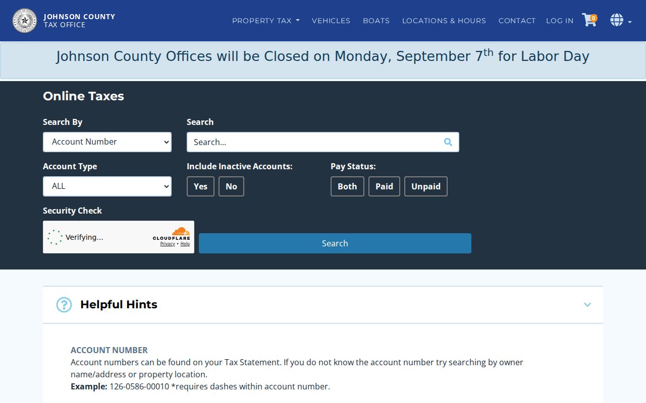
The tax screen reinforces why a street directory must separate a physical location from an owner’s correspondence address. It can support an address trail, but it does not turn the returned account into a complete resident list.